Free UK detecting app

Your detector finds the signal. Understand the ground with FindSpot.

Developed by archaeologists and detectorists. Built for your next permission.

Our engines bring landscape clues, historic context and your field records together. Plan where to look, record what happens and return with a better understanding of the land.

Free · No account · iPhone & Android
First visit? See how to get started →

Bring them together.

LandscapeTerrain, water and routes
Historic contextMapping and recorded archaeology
Your fieldworkFinds, trails and observations
One clearer picture

Explore the evidence behind a suggestion, with uncertainty kept in view.

How the engines work together · explanatory illustration

10,000+ detectorists
Everything free
Zero accounts
Offline recording
Private by default
Your exact finds, permissions and trails remain under your control. Stored locally. No location analytics. No background upload to a FindSpot account. How FindSpot protects your records →

From this page to your first visit.

Open FindSpot in your phone browser to get started. Adding it to your home screen is optional.

2. Keep it to hand

iPhone: in Safari, open Share and choose Add to Home Screen.
Android: look for Install app or Add to Home screen in your browser menu.

3. Prepare before you go

Open your permission and load the maps and FieldGuide information you need while connected. Check what is available offline before leaving, and save regular backups of your records.

FindSpot remembers the land with you.

Understand a permission, work it in the field, preserve what happened and return with more context than you started with.

Plan
Detect
Record
Understand
Return

Understand your permission before you arrive.

A slope. An old route. A water source. A pattern of finds. Our engines bring those clues and more together, using archaeological methods to help you interpret your permission and decide what deserves a closer look.

  • Shows its workingSee what supports an interpretation, what weighs against it and how confident it is.
  • Clues considered togetherMultiple landscape and historic signals are considered together to help focus investigation.
  • Protected landscape awarenessScheduled monument boundaries are visible before you are standing on them.

FieldGuide highlights potential and helps focus your search. It does not guarantee finds.

Every permission has a story.

A plain field becomes more useful when landscape evidence and your own records are viewed together.

Read the shape of the land

Terrain and water context help explain how people may have moved through and used a landscape.

Put clues in context

Historic routes, mapping and recorded archaeology give individual signals a wider setting. See what supports an interpretation and where information is limited.

Build on your own visits

Recorded finds, observations and trails add local context for your next visit. A recorded trail shows where you travelled; it does not prove the ground was fully searched.

Suggestions guide investigation; they are not a probability of finding an object. Missing evidence remains a limitation, not proof that nothing is there.

Your own recorded finds become evidence in FieldGuide.

Use FindSpot, record what happened, build local context and return with better information. Your private find records stay on your device unless you choose to export or share them.

Start detecting. FindSpot changes with you.

Once a visit starts, FindSpot becomes a focused field workspace. Four clear views keep the job simple without losing the context of your session.

  • MapSee your position, permission and recorded trail as you work.
  • RecordSave a find, useful point, surface observation or undug signal quickly.
  • SessionReview the current visit, add notes and finish it clearly.
  • GuideOpen FieldGuide without losing the active session around you.
Field workspace · illustrative layout
Trail recording · GPS liveFinish
Meadow permission 01:24 · 3 finds

Pick up where you left off.

Return to a permission and see the context you have already built locally — previous visits, recorded trails, finds and areas worth another look.

Continue the visitReopen an unfinished session and carry on without rebuilding its context.
See recorded evidenceSee where you've detected before — and the gaps between your recorded trails.
Build on what you knowUse finds, observations and earlier visits to decide what deserves attention next.
FindSpot digital permission proof screen
Permission proofClear information when you need to show you are allowed to be there.

Protect your permissions. Earn more land.

Keep boundaries, proof, agreements and landowner details together, then turn recorded visits into clear field reports.

  • Proof and agreementsKeep clear permission evidence available in the field.
  • Field visit reportsSummarise a visit and the records made there for the person who gave permission.

“The detailed field reports have helped me build a very good relationship with the council — and even secure a couple more areas to detect on.”

Lee W. — council park permission

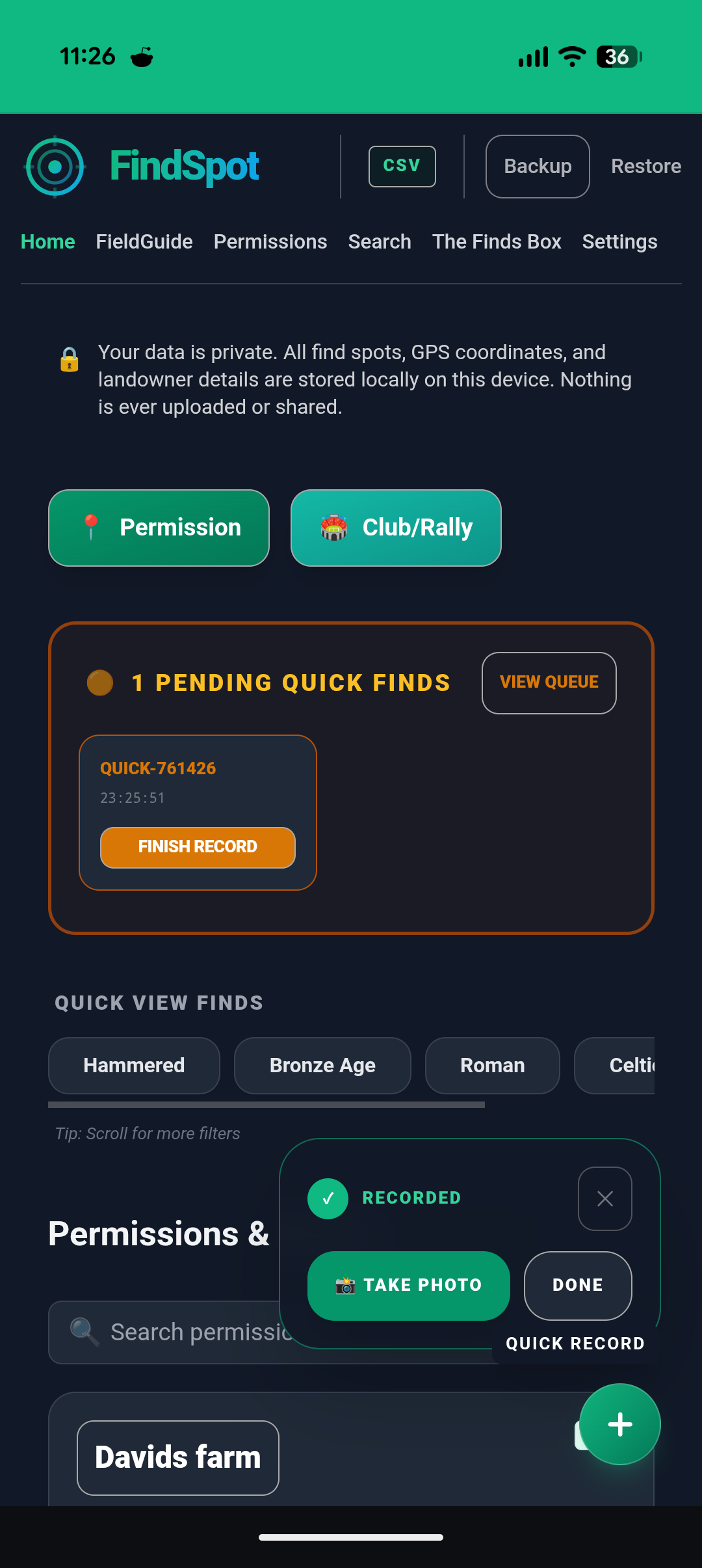
Record the point now. Add detail when it suits you.

Quick Find captures the location first. Complete the photos, material, period, depth, detector context and notes when your hands are free.

  • Fast enough for muddy handsSave the essential context without breaking your detecting rhythm.
  • Useful beyond the recordFinds can support FieldGuide context, visit reviews and landowner reports.
  • Works offlineFind recording, permissions and trail recording keep working without a signal.
FindSpot quick capture interface for recording a find in the field
Quick captureRecord the point first. Add the full find details when it is practical.

When context matters, keep the next step clear.

FindSpot supports responsible handling when a discovery needs more than a normal find record.

Stop & Secure

Protect what may remain

Record the position and preserve context before further disturbance.

Map Scatter

Preserve the pattern

Log separate points before the relationship between them is lost.

Notable Find

Capture what matters

Keep photos, location, context and follow-up details together.

Supports responsible recording. Does not constitute legal or reporting advice.

Detecting with a club? FindSpot does that too.

One QR code. No accounts. Organisers can open a dig, members can record quickly and the day can be reviewed together afterwards.

Your permissions. Your finds. Your control.

Exact find locations, productive fields, permissions, GPS trails and notes stay on your device unless you choose to export, share or submit them.

Local-firstPrivate records live in your device's own database.
No accountsNo FindSpot profile or background sync of your finds.
No location analyticsNo advertising trackers on saved spots, trails or permissions.
You choose what leavesExport or share records only when you decide to.

Private doesn't mean fragile.

Save a user-controlled FindSpot backup before changing phones or whenever your records have changed. FindSpot validates and stages a backup before restoring it, without requiring your private records to be uploaded to a FindSpot account.

Backup remindersValidated restoreExplicit user control

No accounts. No adverts.
No subscriptions. No locked features.

Everything. Free. Always.

Free does not mean your locations or detecting records are being monetised. FindSpot is built to put useful field tools in detectorists' hands without trading away their privacy.

Common questions

Does it work on iPhone and Android?

Yes. FindSpot is a Progressive Web App, so it works in a modern phone browser. On iPhone, open it in Safari and use Add to Home Screen. On Android, your browser will usually offer to install it.

Do I need to create an account?

No. There is no account, login or email required. You can start using FindSpot immediately.

Does it use mobile data in the field?

Find recording and permission management work offline. Load your maps and FieldGuide information while connected, then check what is available before heading out. New landscape data needs a connection. Browser and phone settings can interrupt GPS trail recording, especially when the screen is locked.

What if I lose or replace my phone?

FindSpot supports explicit, user-controlled backups and reminds you when changing records need protection. Save the backup somewhere safe, then use FindSpot's validated restore tools on your replacement device. Recovery is not automatic cloud sync.

Is it really free?

Yes. FindSpot is free to use in full, with no adverts, subscription, locked tier or account requirement.

What is FieldGuide?

FieldGuide analyses terrain, water features, historic routes and recorded archaeology — including Portable Antiquities Scheme data and your own locally recorded finds — and shows the evidence behind its interpretations. It helps focus a search, but it does not guarantee finds.

What if I find something important?

FindSpot includes guided workflows for Stop & Secure, Map Scatter and Notable Find records. They help preserve context and support responsible recording, but they do not replace professional or legal advice.

Don't just detect the land. Understand it.

Open FindSpot on your phone and start building useful context around your permission — privately, with no account.

Open FindSpot free